Identify Major / Minor Terrain Features
Looking for a school where you can use your military benefits? Use are degree finder!
Hill, Ridge, Valley, Saddle, Depression, Draw, Spur and Cliff
Terrain features are identified in the same manner on all maps, regardless of the contour interval, but you must realize that a hill in the Rocky Mountains will be much bigger than one in south Florida. You must be able to recognize all the terrain features to locate a point on the ground or to navigate from one point to another.
The five major terrain features are: Hill, Ridge, Valley, Saddle, and Depression.
The three minor terrain features are: Draw, Spur and Cliff.
Terrain features can be learned using the fist or hand to show what each would look like on the ground.
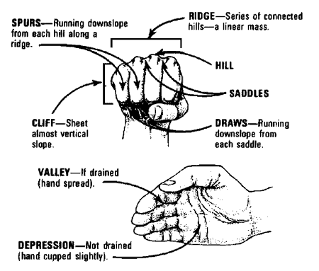
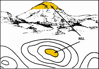
Hill-a point or small area of high ground. When you are on a hilltop, the ground slopes down in all directions.
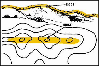
Ridge-a line of high ground with height variations along its crest. The ridge is not simply a line of hills; all points of the ridge crest are higher than the ground on both sides of the ridge.
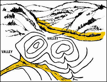
Valley-reasonably level ground bordered on the sides by higher ground. A valley may or may not contain a stream course. A valley generally has maneuver room within its confines. Contour lines indicating a valley are U-shaped and tend to parallel a stream before crossing it. The course of the contour line crossing the stream always points upstream.
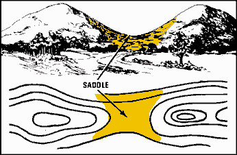
Saddle-a dip or low point along the crest of a ridge. A saddle is not necessarily the lower ground between two hilltops; it may be a break along an otherwise level ridge crest.
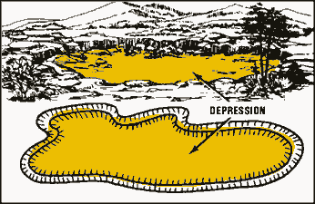
Depression-a low point or hole in the ground, surrounded on all sides by higher ground.
Identify Minor terrain features
Although these features are not as important as the major terrain features, navigators can plan routes more successfully if they can identify all the terrain features their routes will cross over.
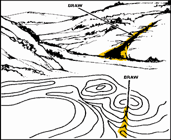
Draw-similar to a valley, except that it normally is a less developed stream course in which there is generally no level ground and, therefore, little or no maneuver room. The ground slopes upward on each side and toward the head of the draw.
Draws are caused by flash floods and can be found on flat terrain but are more often found along the sides of ridges. Contour lines indicating a draw are shaped like a “V” with the point of the “V” toward the head of the draw (high ground).
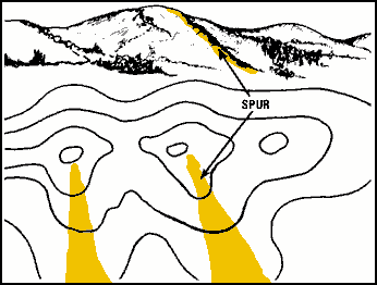
Spur-a usually short, continuously sloping line of higher ground, normally jutting out from the side of a ridge. A spur is often formed by two thoroughly parallel streams cutting draws down the side of a ridge.
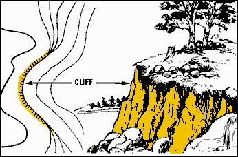
Cliff-a vertical or near-vertical slope. A cliff may be shown on a map by contour lines being close together, touching, or by a ticked “carrying” contour line. The ticks always point toward lower ground.
Financial Aid Info
- Your Guide to Federal Student Loans
- Grants and Scholarships
- Military Benefits
- Private Student Loans
- Repaying Student Loans
- Student Loan Consolidation
- Education Tax Credits | AOTC & LLC
- 15 Military Scholarships to Apply For in 2023
- Grad School Scholarships
- 12 Graduate Scholarships for DACA Students in 2025
- Graduate Scholarships for International Students
- Grants for Women
- Guide Schools & Scholarships for Students with Disabilities
- Guide Tribal Colleges and Scholarships for Native Americans
- 8 Adult Scholarships for Adults Returning to School
- How to Earn Credit for College with Life Experience
- The Psychology of Lying
- 36 Companies That Pay For College
- FAFSA: Parent and Student Assets
- How Do You Get Student Loans Without a Job?
